
Jerteh Travel Guide
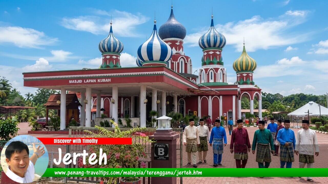 Jerteh Travel Guide (AI generated on 10 September 2026)
Also available: Panduan Melawat Jerteh
Jerteh is a town in the Besut District of northern Terengganu, Malaysia, close to the border with Kelantan. It is the largest and most commercially developed town in Besut, serving as an important centre for shopping, services, education and everyday business in the northern part of the state.1 Although Jerteh is not itself a major resort destination, its position makes it a useful base for exploring the wider Besut area, including Kuala Besut, the gateway to the Perhentian Islands, as well as beaches, waterfalls, forests and other attractions in inland Besut.
Quick Facts
- Location: Besut District, northern Terengganu, Malaysia
- Also spelled: Jertih
- Role: Main commercial and service centre of Besut
- District: Besut
- Local authority: Majlis Daerah Besut (Besut District Council)
- Geographical setting: Inland town between the Kelantan border and the coastal settlements of Besut
- Nearest major coastal gateway: Kuala Besut, the mainland gateway to Pulau Perhentian
- Major road: Federal Route 3, the East Coast Road linking Terengganu with Kelantan
- Notable local landmark: Masjid Hadhari, also known as Jerteh Mosque
- Nearby nature attraction: Lata Tembakah, about 24 km from Jerteh
- Nearest major airport: Sultan Ismail Petra Airport in Kota Bharu, Kelantan
- Future rail connection: Jerteh ECRL station, scheduled to form part of the East Coast Rail Link passenger network
Where is Jerteh?
Jerteh is situated in the northern part of Terengganu, within Besut District and relatively close to the Kelantan border. The town lies inland from the South China Sea, while the coastal town of Kuala Besut is to the east. Kampung Raja, the administrative centre of Besut District, is also nearby.1
The location gives Jerteh an important role that is somewhat different from that of Kuala Besut. Kuala Besut is principally associated with fishing, the coast and access to Pulau Perhentian, whereas Jerteh functions as a commercial and service centre for a much wider inland population. Academic research on Besut's small towns has identified Jerteh, Kampung Raja and Kuala Besut as the district's three principal urban centres, with Jerteh having a particularly important commercial function.2
The town is also strategically positioned on the main north-south road along the east coast. Travellers heading between Kota Bharu and the towns of northern and central Terengganu commonly pass through the Jerteh area. This makes it a practical stopping point on a road journey rather than simply a destination visited for a single attraction.
Geography and surroundings
Jerteh occupies an inland position within a district that contains several contrasting landscapes. The eastern part of Besut reaches the South China Sea, while the interior rises towards forested hills. Rivers, agricultural land, villages and small settlements surround the town.
The Besut landscape becomes increasingly rural outside the built-up area. Paddy fields and villages are interspersed with rubber-growing areas and other agricultural land, while the interior contains forest reserves and recreational areas. This makes Jerteh a convenient transition point between the more urbanised parts of the district and the natural attractions of Hulu Besut.
The Sungai Besut river system is an important geographical feature of the district. Historically, rivers were important transportation routes before modern roads became dominant. The relationship between rivers, settlements and commerce helps explain the development of several older settlements in Besut.
Jerteh itself is not directly on the coast. Travellers wanting to visit the beaches or take a boat to the Perhentian Islands normally continue eastwards towards Kuala Besut. Conversely, visitors interested in waterfalls and forest recreation can travel inland from Jerteh towards areas such as Lata Tembakah and Lata Belatan.
A brief history of Jerteh
The history of Jerteh is closely connected to the wider history of Besut. Written documentation about the early history of Besut is relatively limited, and a number of traditional accounts have been passed down concerning the settlement and political development of the district. Besut subsequently became part of the Terengganu political sphere, while maintaining strong cultural and economic connections with neighbouring Kelantan.
Jerteh developed from a settlement and river-related trading environment into an important town. Its position along the main route between Terengganu and Kelantan encouraged commerce, and the town gradually became a service centre for surrounding villages.
By the twentieth century, Jerteh had developed a recognised commercial role. A study of the economic development of Besut's small towns notes that a weekly market was already being held at Jertih in the 1930s. This provides evidence that the town had become part of the district's commercial network well before modern highways and shopping complexes transformed the area.3
Following the development of modern roads and public facilities, Jerteh increasingly became the main business centre for northern Besut. The Besut District Council identifies Jerteh, Kampong Raja and Kuala Besut as the district's three principal towns, and describes Jerteh as the main town for the northern region of Terengganu.1
How did Jerteh get its name?
The origin of the name Jerteh is not completely established in authoritative historical documentation. The town is also commonly written as Jertih, and both forms have been used in modern references.
One traditional explanation connects the name with an old river landing known as Pengkalan Aji Teh. According to this account, the name was gradually shortened in local speech, eventually producing forms such as “Jiteh” and “Jerteh”. The explanation is part of local oral tradition rather than a firmly documented historical etymology, so it is best regarded as a traditional account rather than an established fact.4
The spelling Jerteh was used historically and remains familiar today, including in the name of the town's major mosque and in older references. The spelling Jertih is also widely used in official and contemporary contexts. Travellers may therefore encounter both spellings when searching for directions, accommodation or transport.
Things to see and do around Jerteh
Masjid Hadhari
Masjid Hadhari is one of the most recognisable landmarks in Jerteh. The mosque stands in Bandar Jerteh and replaced an older mosque to accommodate the growing number of worshippers. The present building was constructed in 2005 and became known as Masjid Hadhari.5
Its prominent domes and minarets make it an easily recognisable feature of the town. For Muslim visitors, it is a place of worship as well as a significant local landmark. Non-Muslim visitors should observe the usual etiquette when visiting a mosque, including appropriate dress and avoiding prayer areas during worship unless permitted.
Masjid Ulul Albab and Masjid Lapan Kubah
The wider Besut area is notable for several distinctive mosques. Among them are Masjid Ulul Albab at Seberang Jerteh and Masjid Lapan Kubah at Kampung Lapan Kotak. They are located outside the immediate town centre but can be incorporated into a driving itinerary around Besut.
These mosques are particularly interesting for visitors interested in Islamic architecture and the religious landscape of Terengganu. They also illustrate how mosques function as important community landmarks throughout the state.
Lata Tembakah
Lata Tembakah is one of the most accessible nature attractions from Jerteh. The forest recreation area is located about 24 km from Bandar Jerteh, inside the Pelagat Forest Reserve. The surrounding forest is classified as hill dipterocarp forest, and the site includes a waterfall, river, trails and areas for swimming, wading and camping.6
The site has facilities including parking, toilets, a surau, shelters, stalls, a hall and accommodation facilities. The Forestry Department currently lists it as open from 8.00am to 5.00pm, although visitors should check current conditions before setting out, particularly during periods of heavy rain.6
Lata Tembakah is best approached by car or other private transport. Although the Forestry Department lists taxi and bus as possible modes of access, public transport within the rural interior is not as convenient as travelling by car.
Other Besut attractions
Jerteh is useful as a base for visiting several attractions elsewhere in Besut. These include Bukit Keluang, Pantai Air Tawar, Lata Belatan, Gunung Tebu, La Hot Spring, Pantai Dendong and Desa Ukiran Kayu. The Besut District Council lists these among the district's principal visitor destinations.7
The most famous destination in the wider district is undoubtedly Pulau Perhentian. Boats to the islands depart from Kuala Besut, which is the principal mainland gateway. A visitor staying in Jerteh can therefore combine a town stay with a separate trip to the islands.
Food in Jerteh
Jerteh's food scene reflects the culinary character of northern Terengganu, while also showing the strong cultural influence of neighbouring Kelantan. Visitors should expect a mixture of Terengganu and Kelantan-style dishes alongside ordinary Malaysian restaurant food.
For breakfast, look for nasi dagang, nasi kerabu, nasi berlauk and other rice-based dishes. Nasi dagang is traditionally prepared with rice cooked in coconut milk and served with fish curry, while nasi kerabu is associated with the distinctive blue rice, herbs and accompaniments of the East Coast.
Other local foods worth trying include laksam, laksa Terengganu, keropok lekor, sata, pulut lepa and various traditional kuih. Besut is also associated with tonyoh ubi kayu, a traditional tapioca-based food eaten with grated coconut.8
For a more local experience, visitors can explore the markets and small food stalls around Jerteh and the surrounding villages. The Besut District Council also maintains a list of night markets in the district, although these are spread among different settlements rather than concentrated entirely in Jerteh.9
Where to stay in Jerteh
Jerteh has a range of accommodation suitable for travellers who prefer to stay in a town rather than at a beach resort. Options include small hotels, budget accommodation and homestays. The town is particularly practical for travellers who are using Jerteh as an overnight stop between Kelantan and the rest of Terengganu.
The Besut District Council's accommodation listings include establishments in Jerteh and the surrounding area, while commercial booking platforms list several hotels in and around the town. Because accommodation availability and operating status can change, travellers should check current listings and recent reviews before booking.10
Staying in Jerteh can also be useful for visitors who plan to explore several parts of Besut by car. Those heading specifically to the Perhentian Islands may instead prefer to stay in Kuala Besut, especially if they have an early boat departure.
How to get to Jerteh
By car
For most visitors, driving is the easiest way to reach Jerteh. The town lies on Federal Route 3, the principal road connecting the east-coast settlements of Peninsular Malaysia. From Kuala Terengganu, the road distance is about 102 km and the journey normally takes around one and a half hours, depending on traffic and weather.11
From Kota Bharu, Jerteh is about 59 km by road and can normally be reached in roughly an hour under ordinary traffic conditions.12 This makes Jerteh particularly convenient for travellers combining northern Terengganu with a visit to Kelantan.
By bus
Long-distance buses serve Jerteh, and the town is connected by road services with Kuala Terengganu and other parts of the East Coast. Direct buses between Jerteh and Kuala Terengganu operate on the route, although schedules vary according to the operator and season.11
For travellers arriving without a car, Jerteh is therefore considerably easier to reach than many of the rural attractions in Hulu Besut. From the town, however, a taxi, e-hailing service where available, or private vehicle is generally more practical for reaching waterfalls, forest recreation areas and dispersed village attractions.
By air
The nearest major airport is Sultan Ismail Petra Airport (KBR) near Kota Bharu. The road distance from Jerteh to the airport is approximately 65 km, making it a practical option for visitors arriving by air from Kuala Lumpur or other Malaysian cities, subject to current flight schedules.13
Sultan Mahmud Airport (TGG) at Kuala Terengganu is another option, particularly for travellers continuing southwards through Terengganu. From the airport, the journey to Jerteh is longer than from Kota Bharu, but it can fit conveniently into an itinerary covering Kuala Terengganu and northern Terengganu.
The East Coast Rail Link and Jerteh
Jerteh is planned to become part of Malaysia's East Coast Rail Link (ECRL). The official ECRL alignment includes a passenger station at Jerteh, making it one of six ECRL stations planned for Terengganu. The other Terengganu stations are Bandar Permaisuri, Kuala Terengganu, Dungun, Kemasik and Chukai.14
As of 2026, the ECRL is still under construction and should not be treated as an operating railway service. Malaysia Rail Link has stated that the Kota Bharu–Gombak section is scheduled for completion in December 2026 and is expected to begin operations in January 2027.14
Once operational, the Jerteh station should improve rail access to northern Terengganu and strengthen the town's position as a transport centre between Kelantan and the rest of the East Coast.
Getting around Jerteh
The central commercial area of Jerteh is compact enough to explore on foot if the visitor's purpose is shopping, eating or seeing the town centre. However, the wider area is spread out, and most attractions are not within comfortable walking distance.
A car is the most useful form of transport for visitors who want to explore Jerteh and the surrounding Besut countryside. It allows travellers to combine several destinations in a single day, such as Jerteh, Kampung Raja, Kuala Besut and Lata Tembakah.
Taxis and other hired transport can also be useful for visitors without a vehicle. For trips to rural waterfalls or forest areas, it is advisable to arrange return transport in advance rather than assuming a vehicle will be readily available at the destination.
Jerteh as a base for the Perhentian Islands
Although Jerteh is inland, its proximity to Kuala Besut gives it an indirect connection with one of Terengganu's best-known tourist destinations, the Perhentian Islands. Kuala Besut is the principal mainland departure point for boat services to the islands.15
For travellers arriving late in the day or looking for more affordable accommodation away from the coastal resort area, Jerteh can serve as an overnight base. However, visitors with an early morning boat departure should consider staying closer to Kuala Besut, particularly during periods when road travel may take longer than expected.
How long should you stay?
For most travellers, one night is sufficient for Jerteh itself. The town is primarily a commercial centre rather than a destination where visitors need several days to see a long list of attractions.
A longer stay becomes worthwhile if Jerteh is used as a base for exploring Besut. A two- or three-day itinerary could combine the town and its mosques with Lata Tembakah, other inland recreation areas, Kuala Besut and the beaches of the district.
Suggested one-day itinerary
- Morning: Have breakfast in Jerteh and explore the town centre.
- Late morning: Visit Masjid Hadhari and, if time permits, other distinctive mosques in the surrounding area.
- Lunch: Try a local rice dish such as nasi dagang or nasi kerabu.
- Afternoon: Travel to Lata Tembakah for a forest and waterfall experience, allowing sufficient time for the return journey.
- Evening: Return to Jerteh for dinner or continue towards Kuala Besut for an overnight stay.
Best time to visit Jerteh
Jerteh can be visited throughout the year, but weather is particularly important when planning outdoor activities. The east coast of Peninsular Malaysia is affected by the Northeast Monsoon, which can bring heavy rain and rough sea conditions from roughly November to February.
For a trip that combines Jerteh with beaches, islands and waterfalls, the drier months are generally more convenient. Conditions can still change quickly, however, and visitors should check weather forecasts before travelling to forest and waterfall areas.
If travelling to the Perhentian Islands, remember that boat operations are more directly affected by sea conditions than activities in Jerteh itself. During periods of rough seas or monsoon weather, island services may be reduced or suspended.
Practical travel tips
- Use Jerteh as a base: It is particularly useful for exploring inland and coastal Besut by car.
- Plan rural excursions: Attractions such as Lata Tembakah are outside the town and require additional travel time.
- Carry cash: Small food stalls, markets and rural facilities may not accept cards.
- Respect mosque etiquette: Dress appropriately and follow local rules when visiting mosques.
- Check weather conditions: Heavy rain can affect waterfalls, roads and outdoor activities.
- Book island accommodation separately: Jerteh is on the mainland, while the Perhentian Islands require a boat transfer from Kuala Besut.
- Allow extra travel time: Road conditions, traffic and weather can affect journey times along the East Coast Road.
- Check transport schedules: Bus and boat schedules can change, particularly outside peak travel periods.
Why visit Jerteh?
Jerteh is best understood not as a conventional resort town but as a regional centre in northern Terengganu. Its importance comes from its position, commercial activity and connections with the surrounding communities of Besut. It is also one of the more useful stopping points for travellers crossing between Kelantan and Terengganu.
The town becomes more interesting when viewed together with its surroundings. Within a relatively manageable driving area are distinctive mosques, traditional food, villages, beaches, forests, waterfalls, hot springs and the gateway to the Perhentian Islands. The planned ECRL station is also likely to strengthen Jerteh's role as a northern Terengganu transport centre in the coming years.
For visitors travelling along the East Coast of Peninsular Malaysia, Jerteh therefore offers something different from the better-known beach destinations: it provides an opportunity to experience the everyday commercial and cultural life of Besut while remaining close to some of northern Terengganu's most notable natural attractions.
References
- Majlis Daerah Besut — Latar Belakang
- Universiti Kebangsaan Malaysia — Perkembangan dan cabaran sektor perniagaan sebagai pemangkin pembangunan bandar kecil: kajian empirikal di Daerah Besut, Terengganu
- University of Malaya — Sejarah, Journal of History Department, Vol. 31 No. 1
- Small Towns Malaysia — Jerteh, Terengganu
- Jabatan Kemajuan Islam Malaysia — Masjid Hadhari, Bandar Jerteh
- Jabatan Perhutanan Semenanjung Malaysia — Lata Tembakah Forest Eco Park
- Majlis Daerah Besut — Places of Interest
- Beautiful Terengganu — Tonyoh Ubi Kayu
- Majlis Daerah Besut — Makan
- Majlis Daerah Besut — Penginapan
- Rome2Rio — Jertih to Kuala Terengganu
- Rome2Rio — Jertih to Kota Bharu
- Rome2Rio — Jertih to Sultan Ismail Petra Airport
- Malaysia Rail Link — ECRL information and Terengganu stations
- Majlis Daerah Besut — Pengangkutan
Page Details
This page was created on 10 September 2026. Hi, my name is Timothy and created it from my research, for my own entertainment, knowledge and to satisfy my curiosity. I am providing the information to you in good faith and hope it is useful. I try to get the details as accurate as possible. I also try to update the page whenever I stumble on new details. So this and all my other pages are perpetual work in progress. If you discover any error, please politely inform me, pointing out where the error lies, and I will correct it as soon as possible. Your helpfulness will keep this page accurate, relevant and helpful to those who need the information.Buy Me A Coffee
If you enjoy the information I provide and want to support the work I do, please buy me a coffee! I appreciate it immensely, thank you so much!
