
Sungai Siput Travel Guide
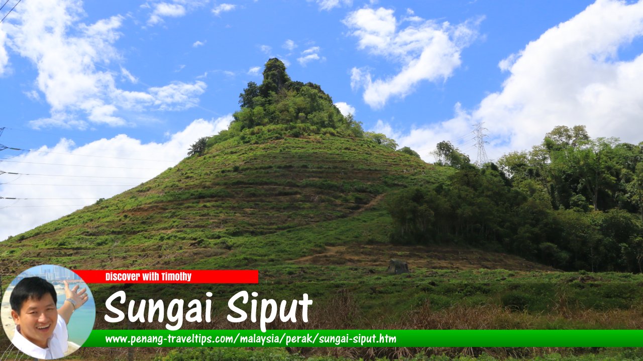 View of Lion Hill in Sungai Siput, Perak (18 September, 2016)
Also available: Panduan Melawat Sungai Siput
Sungai Siput is a small town and mukim in Kuala Kangsar District, Perak, Malaysia. Located between Ipoh and Kuala Kangsar, it is a town with a distinctive history shaped by tin mining, rubber plantations, agriculture and the development of the railway. Today, Sungai Siput provides an interesting base for exploring the northern part of the Kinta Valley and the rural landscapes of central Perak.
The town is surrounded by hills, plantations, villages, former mining areas and forest. The wider Sungai Siput mukim is particularly rural, with a large proportion of forest and Orang Asli settlements. The area is also known for agricultural products, including groundnuts, while the surrounding limestone landscape provides a striking natural backdrop.
Quick Facts
Town: Sungai Siput (U), commonly known simply as Sungai Siput
State: Perak
District: Kuala Kangsar
Coordinates: Approximately 4.819°N, 101.076°E
Local authority: Kuala Kangsar Municipal Council
Geographical character: Town, agricultural land, plantations, limestone hills and forest
Historical industries: Tin mining and rubber cultivation
Rail connection: Sungai Siput railway station
Nearby major towns: Ipoh and Kuala Kangsar
Known for: Tin-mining heritage, rubber estates, groundnuts, limestone hills and its association with the beginning of the Malayan Emergency
Where Is Sungai Siput?
Sungai Siput is in the southern part of Kuala Kangsar District, north of Ipoh and south of Kuala Kangsar. It lies along the main north-south transportation corridor formed by Federal Route 1 and the railway line.
The town's surroundings are more rural than those of Ipoh. Moving away from the town centre, the landscape changes into plantations, agricultural land, villages, forest and hills. The wider mukim is one of the largest administrative areas within Kuala Kangsar District. According to the Perak land administration, the mukim covers about 96,053 hectares, with hilly terrain and approximately two-thirds of its area consisting of forest reserves and Orang Asli settlement areas.
This geographical setting gives Sungai Siput a different atmosphere from the larger cities of Perak. It is suitable for travellers interested in rural landscapes, local history, food and the quieter side of the state.
Why Visit Sungai Siput?
Sungai Siput is not a major resort destination and does not have a long list of conventional tourist attractions in its town centre. Its interest lies instead in its combination of history, landscape and local culture.
- Explore a former tin-mining and rubber-growing town.
- Learn about the historical events of 1948 that preceded the Malayan Emergency.
- See limestone hills and rural landscapes around the town.
- Experience a smaller Perak town away from the main tourist centres.
- Sample local agricultural produce, particularly groundnuts.
- Visit nearby waterfalls and recreational areas.
- Use Sungai Siput as a base for exploring northern Kinta Valley and parts of Kuala Kangsar District.
- Combine a visit with nearby Kuala Kangsar, Karai and the Victoria Bridge.
The Meaning of Sungai Siput
The Malay name Sungai Siput literally means "Snail River". The name is associated with the river in the area, which was traditionally known for the presence of snails. Local historical accounts describe the watercourse near the town as the source of the name.
The town is officially distinguished as Sungai Siput (U), with the letter U standing for Utara (North). This distinguishes it from another locality called Sungai Siput in Perak.
The name is also commonly rendered in Chinese as 和丰, traditionally associated with the town's Chinese community and its history as a mining settlement.
Early Settlement
The history of Sungai Siput predates the development of the modern town. One account places an early settlement at Pelang, about two kilometres from the present town centre. The settlement was associated with Minangkabau families who had earlier established themselves in the Sayong area.
The modern town developed more rapidly during the expansion of tin mining in Perak. By the late nineteenth and early twentieth centuries, Chinese miners and traders had become an important part of the local economy. Sungai Siput subsequently developed as a commercial centre serving the surrounding mining, agricultural and plantation communities.
Tin Mining in Sungai Siput
Tin was one of the most important industries in Sungai Siput's early development. The town lies within the broader geological environment of the Kinta Valley, one of the world's historically important tin-producing regions.
Limestone hills around Sungai Siput are part of the geological landscape associated with the Kinta Valley. Tin-bearing deposits were worked in the region from the nineteenth century onwards, contributing to the growth of settlements and transportation infrastructure.
Mining also helped connect Sungai Siput with the developing railway system. Railways were particularly important because tin ore and other commodities had to be transported from inland mining districts towards the ports and commercial centres of the west coast.
Evidence of the region's mining past can still be seen in the landscape, although many former mining areas have since been transformed into agricultural land, settlements or other uses.
Rubber and Plantation Agriculture
After the expansion of the tin industry, rubber became another important component of Sungai Siput's economy. British-owned estates were established around the town and employed large numbers of workers.
Rubber plantations became an important part of the landscape during the first half of the twentieth century. Even today, plantations remain an important feature of the countryside surrounding Sungai Siput, although the agricultural economy has diversified considerably.
The plantation economy also contributed to the development of roads, railway connections, schools, places of worship and commercial services in the area.
The Sungai Siput Incident of 1948
Sungai Siput occupies an important place in the history of modern Malaysia because of events that occurred here in June 1948.
On 16 June 1948, three European plantation managers were killed in attacks at two rubber estates in the Sungai Siput area. The victims were A. E. Walker, manager of Elphil Estate, and John Allison and his assistant Ian Christian at Phin Soon Estate. The attacks became one of the immediate events leading to the declaration of the Malayan Emergency.
The Emergency was subsequently proclaimed by the colonial administration as the communist insurgency escalated. It lasted from 1948 until 1960 and profoundly affected the political, social and economic development of Malaya.
Because of these events, Sungai Siput frequently appears in historical accounts of the Emergency. The subject is politically and historically complex, and visitors interested in it should consult historical sources representing different perspectives rather than relying on a single narrative.
Sungai Siput Today
Modern Sungai Siput remains a small commercial and administrative centre serving a large rural hinterland. The town centre contains shops, restaurants, banks, schools, government facilities, places of worship and other services used by residents from surrounding villages and plantations.
The economy is no longer dependent on tin mining. Agriculture, plantation activities, manufacturing, commerce and services are now more important to the local economy.
The town nevertheless retains the character of an old Perak mining settlement. Older commercial buildings and shop lots can be found alongside newer residential developments and commercial premises.
Groundnuts and Local Agriculture
Sungai Siput has long been associated with the production of groundnuts, or peanuts. The crop became one of the agricultural products for which the area was known, alongside other crops grown in the surrounding countryside.
Travellers may encounter peanuts and other agricultural products associated with Sungai Siput in local shops and markets. For visitors interested in food heritage, this provides a simple way to connect the modern town with its agricultural background.
The Limestone Landscape
One of the most distinctive geographical features around Sungai Siput is its limestone terrain. Limestone hills and karst formations rise above parts of the surrounding landscape, reflecting the geological history of the Kinta Valley.
These hills are more than scenic landmarks. Limestone formations influence local ecosystems, drainage and land use, and they form part of the broader karst landscape that characterises several parts of Perak.
Travellers should not assume that every limestone hill is accessible. Many are within privately owned land, plantations, quarries, forest reserves or environmentally sensitive areas. Visitors should use established access routes and observe local restrictions.
Nature and Outdoor Recreation
The countryside surrounding Sungai Siput offers opportunities for visitors who prefer rivers, waterfalls, forest and rural scenery rather than urban sightseeing.
Lata Ulu Chepor
Lata Ulu Chepor is a popular recreational waterfall area in the wider Chemor–Sungai Siput side of northern Kinta Valley. The site consists of a river with cascades and small waterfalls surrounded by greenery. Tourism Perak's Kinta Valley National Geopark material describes a trail of about 500 metres passing small falls and cascades, with facilities including camping areas, chalets, a surau, a children's playground and a food court.
Ulu Chepor is better regarded as a nature and recreation destination than as an attraction in the Sungai Siput town centre. Conditions and facilities can change, particularly during periods of heavy rain, so visitors should check local conditions before travelling.
Rural Forest and Hill Areas
Beyond the town and plantation belt are extensive forested areas and Orang Asli settlements. The official land administration describes the Sungai Siput mukim as predominantly hilly, with substantial forest reserves and Orang Asli areas.
These areas are suitable for travellers seeking a rural experience, but independent exploration should be approached cautiously. Some roads are narrow plantation or village roads, while access to forest areas may require permission.
Kanthan and the Northern Kinta Valley
The Kanthan area south of Sungai Siput is known for its limestone landscape and Hindu religious heritage, including the Kanthan Sri Kallumalai Maha Kaliamman Temple. The temple is one of the religious sites associated with the wider Sungai Siput area.
Visitors should remember that Hindu temples are active places of worship rather than simply tourist attractions. Appropriate clothing, respectful behaviour and observance of any temple rules are important.
Victoria Bridge at Karai
Victoria Bridge at Karai is one of the most interesting historical attractions that can be combined with a visit to Sungai Siput. The bridge crosses the Perak River in the nearby Karai area of Kuala Kangsar District.
Built between 1897 and 1900, the 353-metre single-track railway bridge was constructed during the development of Perak's railway network and the expansion of the tin industry. It was opened during the reign of Sultan Idris Murshidul Adzam Shah I. The bridge is no longer used for railway traffic but has become a heritage attraction.
Victoria Bridge is especially interesting when viewed as part of the history of Sungai Siput and the surrounding mining districts. The railway helped connect inland mining areas with the wider transportation network of Perak.
Kuala Kangsar
Sungai Siput can easily be incorporated into a wider visit to Kuala Kangsar, the royal town of Perak. Kuala Kangsar lies to the north and has a substantially different character, centred on the Perak royal institution, traditional crafts and historic architecture.
Major attractions include Masjid Ubudiah, Istana Kenangan, the Sultan Azlan Shah Gallery, the Kuala Kangsar Clock Tower and the traditional pottery associated with Labu Sayong. The Kuala Kangsar Municipal Council identifies royal tourism as a major focus for Kuala Kangsar while eco-tourism is particularly associated with Sungai Siput and Padang Rengas.
Because the two areas complement each other, travellers with a full day can combine Sungai Siput's mining, plantation and rural character with Kuala Kangsar's royal heritage.
Food in Sungai Siput
Sungai Siput has the type of local food scene normally found in a small Malaysian town rather than a dedicated tourist destination. Coffee shops, Malay eateries, Indian-Muslim restaurants, Chinese restaurants, stalls and small family-run businesses provide everyday meals for residents.
Visitors should look for local breakfast dishes, noodles, rice dishes, Indian-Muslim food, Chinese hawker food and snacks associated with Perak's multi-ethnic food culture.
Groundnuts are particularly relevant to the town's agricultural identity. Packaged peanuts and other locally produced agricultural snacks may make practical souvenirs for visitors.
Food for Muslim Travellers
Muslim travellers should find a range of Malay and Indian-Muslim food establishments in and around Sungai Siput. There are also mosques serving the local Muslim community.
For a specific restaurant, however, halal status should be confirmed directly rather than assumed from the appearance or name of the establishment. Travellers who require certified halal food should look for the appropriate Malaysian halal certification or choose established Muslim-owned eateries.
Mosques and Prayer Facilities
Sungai Siput has a long-established Muslim community. One particularly interesting historical example is Masjid India Muslim Sungai Siput on Jalan Besar. The Department of Islamic Development Malaysia's mosque database records the present mosque building as dating from 1991 and documents an earlier history of Indian Muslim plantation workers and a surau established in the area in 1923.
Muslim visitors can therefore combine sightseeing with visits to local mosques, particularly when travelling through the town during prayer times.
As with any journey through a smaller town, it is sensible to plan prayer stops when travelling into rural or forested areas, where facilities may be less frequent.
Getting to Sungai Siput
By Car
Sungai Siput is conveniently located along Federal Route 1, the historic north-south road through the west coast of Peninsular Malaysia.
From Ipoh, travellers can follow the road north towards Sungai Siput. From Kuala Kangsar, Federal Route 1 provides a direct connection southwards.
The North-South Expressway does not pass directly through Sungai Siput. Drivers using the expressway can leave the highway at a suitable interchange and continue towards Sungai Siput using the local road network.
By Train
Sungai Siput has its own railway station on the electrified KTM railway network. The station serves the town and surrounding communities and is an option for travellers who prefer to arrive by train rather than drive.
KTM services include the northern railway network, although the exact services stopping at Sungai Siput vary by timetable. Travellers should check the current KTM schedule when planning their journey rather than relying on an old timetable. The railway is particularly useful for combining Sungai Siput with Ipoh, Kuala Kangsar and other towns along the route.
By Bus
Local and regional buses connect Sungai Siput with nearby towns, although services are generally less convenient for sightseeing than travelling by car. Visitors intending to explore waterfalls, plantations or rural attractions should consider arranging private transport.
Getting Around Sungai Siput
The town centre can be explored relatively easily by car, motorcycle or on foot, depending on the destination. For attractions outside the town, however, a car is much more practical.
Ride-hailing availability may be more limited than in Ipoh. Travellers who arrive by train and plan to explore rural attractions should therefore make transport arrangements in advance.
Motorcyclists can enjoy the quieter roads around the town, but should take extra care on plantation roads, particularly after rain.
Where to Stay
Sungai Siput has a smaller accommodation market than Ipoh or Kuala Kangsar. Travellers looking for simple accommodation can consider staying in the town, while those seeking a larger selection of hotels may choose Ipoh or Kuala Kangsar.
Staying in Sungai Siput is most useful for visitors who want to explore the surrounding countryside at a relaxed pace or who are travelling through northern Kinta Valley.
For Local Travellers
For travellers from elsewhere in Malaysia, Sungai Siput works well as a short excursion from Ipoh or Kuala Kangsar.
A day trip can combine a walk around the town, local food, a visit to a nearby recreational area and a drive through the surrounding plantation and limestone countryside. Visitors with more time can continue towards Karai and Victoria Bridge or Kuala Kangsar.
The town is also suitable for travellers interested in the history of Perak's mining and plantation economy. Rather than looking for a single major attraction, the most rewarding approach is to view Sungai Siput as a historical landscape made up of many smaller elements.
For Foreign Travellers
Foreign visitors who have already explored Kuala Lumpur, Penang and Ipoh may find Sungai Siput interesting as an introduction to a less tourist-oriented part of Perak.
The town provides an opportunity to see an everyday Malaysian settlement shaped by several major historical forces: Chinese tin mining, British plantation agriculture, Indian plantation migration, Malay and indigenous communities, railway development and the political upheavals of the twentieth century.
Visitors should not expect a heavily commercialised tourist destination. English is understood in many businesses, but travellers going into smaller villages and rural areas may find that communication is easier with some basic Malay.
Suggested One-Day Itinerary
Morning: Begin in Sungai Siput town. Explore the older commercial area, have breakfast at a local coffee shop and learn about the town's mining and plantation history.
Late morning: Visit a local place of worship or another point of historical interest, depending on your interests.
Lunch: Try local Malay, Indian-Muslim or Chinese food in town.
Afternoon: Drive into the surrounding countryside. Depending on weather and access conditions, visit a nearby recreational or waterfall area.
Late afternoon: Continue towards Karai and Victoria Bridge, or travel north towards Kuala Kangsar.
Evening: Return to Sungai Siput or continue to Ipoh or Kuala Kangsar for accommodation.
Suggested Two-Day Itinerary
Day 1 – Sungai Siput: Explore the town and learn about its tin-mining, rubber and Emergency-era history. Spend the afternoon exploring the countryside and nearby recreational areas.
Day 2 – Karai and Kuala Kangsar: Visit Victoria Bridge at Karai, then continue to Kuala Kangsar to explore its royal heritage, historic mosques and traditional crafts.
Best Time to Visit
Sungai Siput can be visited throughout the year. For general sightseeing, mornings and late afternoons are more comfortable than the hottest part of the day.
If waterfalls and outdoor recreation are part of your itinerary, weather becomes more important. Heavy rainfall can make rivers rise quickly and trails slippery. Visitors should avoid entering rivers or waterfalls when water levels are rising or when there has been heavy rain upstream.
The drier periods are generally more comfortable for exploring rural roads, although Malaysia's tropical weather means that rainfall can occur at any time.
Practical Tips
- Bring cash for smaller food stalls and businesses.
- Carry drinking water when travelling into rural areas.
- Do not enter rivers or waterfalls during heavy rain or sudden changes in water level.
- Use established roads and trails when exploring natural areas.
- Respect private plantation land and Orang Asli settlements.
- Dress appropriately when visiting mosques and temples.
- Check train schedules before travelling by KTM.
- Consider using a car if you want to explore attractions outside the town.
- Do not assume that every rural attraction is open every day.
How Long Should You Stay?
For most visitors, one day is enough to experience the town and some of its surroundings. A second day becomes worthwhile if you want to explore the countryside, visit Karai and Victoria Bridge, or combine Sungai Siput with Kuala Kangsar.
Sungai Siput is therefore best understood as part of a wider central Perak itinerary rather than as a destination requiring a long stay on its own.
Sungai Siput as a Historical Landscape
The main attraction of Sungai Siput is arguably its history rather than any single monument. The town brings together several layers of Perak's development.
The limestone landscape provided the geological conditions associated with mining. Tin attracted miners and merchants. Rubber plantations transformed the surrounding countryside and brought workers from different parts of Asia. Railways connected the district with the rest of the peninsula. The events of 1948 placed the name of Sungai Siput in the history of the Malayan Emergency.
Today, the mines and plantations no longer dominate the local economy in the same way, but their influence remains visible in the landscape, settlement patterns, railway infrastructure and cultural diversity of the area.
Nearby Destinations
- Kuala Kangsar: Perak's royal town, known for its royal institutions, historic mosques, museums and traditional crafts.
- Karai and Victoria Bridge: A historic railway bridge over the Perak River, associated with the development of Perak's railway and mining industries.
- Ipoh: Perak's state capital, with extensive colonial, mining, food and limestone heritage.
- Lata Ulu Chepor: A waterfall and recreational area in the northern Kinta Valley.
- Kanthan: A limestone area south of Sungai Siput with religious and geological interest.
Final Thoughts
Sungai Siput is a useful destination for travellers who want to see a quieter and more historically layered side of Perak. It does not compete with Ipoh or Kuala Kangsar in the number of conventional tourist attractions. Instead, its appeal comes from its setting, local communities and connection with some of the defining economic and political developments of Perak.
For a visitor interested in history, the town offers a particularly interesting journey from the tin-mining era through the plantation economy and railway development to the events of the Malayan Emergency. For nature lovers, the surrounding limestone hills, forests, rivers and waterfalls provide another reason to explore the area.
Combined with Karai, Victoria Bridge, Kuala Kangsar and northern Kinta Valley, Sungai Siput can form part of a rewarding central Perak road trip that goes beyond the state's better-known tourist centres.
Map of Sungai Siput, Perak
Sights in Sungai Siput, Perak
- Gurdwara Sahib Sungai Siput (GPS: 4.8153, 101.07857)

- Masjid India Muslim Sungai Siput Utara (GPS: 4.82205, 101.06824)

- Merdeka Clocktower of Sungai Siput Utara (GPS: 4.81727, 101.07733)

- Sri Maha Mariamman Devasthanam (GPS: 4.82444, 101.06456)

- Sri Subramaniam Alayam Devasthana Paripalana Saba (GPS: 4.82086, 101.07118)

- Sungai Siput Hospital (GPS: 4.82794, 101.05705)

Sungai Siput is  on the Map of towns in Perak
References
- Sungai Siput, Perak – Penang Travel Tips
- Pejabat Tanah dan Galian Perak – Pentadbiran Mukim Sungai Siput
- Majlis Perbandaran Kuala Kangsar – Tourism Map
- Kerajaan Negeri Perak – My Local Stats: Kuala Kangsar
- Tourism Perak – Kinta Valley National Geopark
- Jabatan Kemajuan Islam Malaysia – Masjid India Muslim Sungai Siput
- Keretapi Tanah Melayu – Perak Rail Tourism / ETS Information
- Kerajaan Negeri Perak – My Local Stats: Kuala Kangsar 2020
Page Details
This page was created on 15 September 2026. Hi, my name is Timothy and created it from my research, for my own entertainment, knowledge and to satisfy my curiosity. I am providing the information to you in good faith and hope it is useful. I try to get the details as accurate as possible. I also try to update the page whenever I stumble on new details. So this and all my other pages are perpetual work in progress. If you discover any error, please politely inform me, pointing out where the error lies, and I will correct it as soon as possible. Your helpfulness will keep this page accurate, relevant and helpful to those who need the information.Buy Me A Coffee
If you enjoy the information I provide and want to support the work I do, please buy me a coffee! I appreciate it immensely, thank you so much!
